Digital Story: https://arcg.is/vTHiG
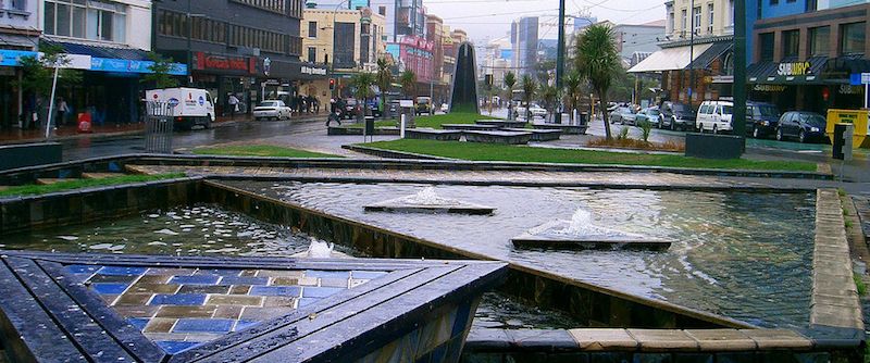
The space/place I chose for this project was the Te Aro Park, also known as the Pigeon Park, located at the intersection of Taranaki St, Manners St and Dixon St in Wellington, New Zealand. I chose this particular space/place as it is one Wellington’s most misrepresented and misinterpreted locations due to its current image that it portrays. Te Aro Park is particularly interesting to me as it is an everyday feature of my life as it lies within my route to and from University. I often hear stories about the abundance of homelessness and poverty displayed in the park, criminal activities and general unappealing aesthetics but, to me, the park is much more than that and I want to make the park’s true meaning and significance known to other Wellingtonians who hold a negative view.
Shona Rapira Davies designed this park as a waka to reflect the Maori whanau of Ngati Ruanui and Taranaki Iwi who occupied the Te Aro Pa and were the first to thrive in the land of the Wellington Region. The representation of the rich history of Te Aro Pa was Davies’ primary intention; however, over time the park became a focal point for the homeless and poverty stricken. It became a location of criminal behaviour resulting in the portrayal of a strong negative view amongst the Wellington public. To many Wellingtonians, this is all they know and understand about the park. They hold a negative view of the park breaking the link between today’s society and the deep history it’s intended to represent. In a Dominion Post article, written by Andrea O’Neil, the park is described as “embarrassing” and a “both up” which gained support from Wellingtonians as an anonymous writer explains “it does a terrible job of marking Te Atiwawa’s former occupation of the site” and another writer claiming, “the whole thing should be demolished.” It is clear that the intended representation was pure and thoughtful, however, the intended representation has not been upheld by those who occupy the location and it is important that Wellingtonians understand that although it may not be represented in the way it deserves, the preservation of its history, through knowledge and understanding, is vital in keeping that history alive. This links into Goggin et al’s idea of the physical elements of a place provides meaning and opens the door to interpretation (Goggin et al 44) and ties into a level of surveillance and behavioural norms.
Like social surveillance, explained by Alice Marwick as “the use of Web 2.0 sites like Twitter, Facebook and Foursquare to see what friends, family, and acquaintances are up to” (Marwick 378), we can see a correlation in the real word when looking at Te Aro Park. As a passer-by, Te Aro Park is observed just like a family member or friend passing by your Facebook page. The passer-by is taking in all the content that is in front of them and that, in turn, creates a negative view of Te Aro Park. Not only do the physical elements of Te Aro Park create a negative view through surveillance, it also develops negative behavioural norms that turn people away and create, once again, a negative view of the park. The general people that occupy the park have created such negative and, sometimes, criminal behavioural norms that most Wellingtonians would feel out of place and, in this case, unsafe. So, through the physical elements affecting the misrepresentation of this park, Wellingtonians develop a negative view through the surveillance and behavioural norms that have been created.
The story I want to convey to people (Wellingtonians especially) is that everything we see around us as Wellingtonians, from buildings, parks and roads, are linked back to this location. The Te Aro Park. It is here that Wellington was born. When the Maori people of Ngati Ruanui and Taranaki Iwi began to thrive in this location, the value of the land increased drastically. European settlers, who were rapidly expanding, quickly took notice of this fact and purchased the land from the Ngati Ruanui and Taranaki Iwi for two horses and carts, two steel mills and allocated the Maori people a 526-acre block of land in 1847 by Governor George Grey. It is from that moment in 1847 that Maori and Europeans lived and worked together to build the city that we live in today. This somewhat ties into Thomas Gieryn’s idea that space is detached from interpretation which emphasises the fact that the park itself is open to interpretation but the land and “abstract geometries” that the park sits on does not allow for interpretation (Gieryn 465). Every time we think of, look at or visit the Te Aro Park, that is the story we should remember, not the embarrassing botch up that Wellingtonians think should be destroyed altogether. If Wellingtonians continue to hold a negative view of this location, our city’s deep history will be forgotten which is why my story is so important.
Through interacting with my Digital Story, the users should have opened their eyes to the deeper picture. They should be able to look past the surface and understand the deep history and its importance to our beautiful city. Although the digital story does not contain thousands of words describing the rich history of Te Aro Park, it should have sparked a fire within to encourage further exploration which can be assisted through following hyperlinks scattered within the digital story. Everything needs a story so let’s make sure Te Aro Park’s true story lives on.
Works Cited:
Gieryn, Thomas. ‘A Space for Place in Sociology’, Annual review of sociology, Vol. 26, No. 1, 2000, p. 465.
Goggin, Gerard. Martin, Fiona. Dwyer, Tim. ‘Locative News: Mobile Media, Place Informatics, and Digital News’, Journalism Studies, Vol. 16, No. 1, 2015, p. 44.
Marwick, Alice. ‘The Public Domain: Social Surveillance in Everyday Life’, Surveillance & Society, Vol. 9, No. 4, 2012, p. 378.